
I’ve always been obsessed with rocket launches. Ever since I was a kid, I’d sit glued to the screen, waiting for that final countdown “5, 4, 3, 2, 1…” and boom, the rocket would take off, fire trailing, heading straight for space. Total goosebumps every single time.
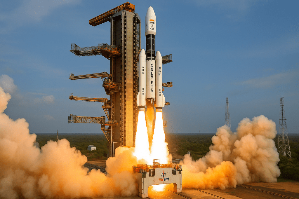
Recently, my feed was full of videos from the GSLV-F16 launch and yeah, I watched it on loop. That usually happens whenever ISRO launches something big. But this time, I got curious. I wanted to know what exactly went up.
So I started digging. And what I found honestly surprised me.
The rocket was carrying a satellite called NISAR, built by ISRO and NASA. And guess what it’s not just some fancy space mission. NISAR is going to help with climate monitoring, agriculture forecasting, and even forest and biodiversity conservation.
Now that got me hooked.
In class, we’re often taught that satellites are used for crop monitoring. But they don’t really go deep into how that works. What kind of data do satellites collect? What do those images even mean for a farmer on the ground?
So I thought, why not write a blog? This time, I want to explore the technical side a bit more break down how a satellite like NISAR, using terms like L-band, S-band, and radar swaths, can actually help in fields, forests, and climate studies.
Let’s get into it.
What Exactly Is NISAR?
Alright, so let’s talk about the star of the launch NISAR.
The full form is kinda long: NASA-ISRO Synthetic Aperture Radar. But don’t let that scare you off. At its core, NISAR is an Earth observation satellite a high-tech eye in the sky that’s built to monitor what’s happening on the Earth’s surface.
It’s a joint project between NASA and ISRO, and honestly, it’s a big deal. Why? Because it’s the world’s first satellite equipped with dual-frequency SAR that’s short for Synthetic Aperture Radar.
Here’s the cool part:
NASA provided the L-band radar (which can penetrate deeper into the Earth’s surface, even through thick vegetation or loose soil).
ISRO added the S-band radar (which captures surface-level changes like crop growth or land shifts).
And both of these radars are connected to a giant 12-meter wide mesh antenna that literally unfolds in space like an umbrella.
Thanks to this setup, NISAR can detect even tiny movements on Earth as small as a few centimeters. That means it can spot soil shifting after a landslide, ice sheets melting slowly over months, crops growing or drying out over time, even tree loss in forests.
And the best part? It will scan almost the entire globe every 12 days in any weather, day or night.
So basically, this satellite doesn’t sleep. It’s watching, recording, and collecting data non-stop which is great news for researchers, farmers, disaster response teams, and honestly… anyone who cares about the planet.
NISAR’s Superpowers What Makes It Special
So, what makes NISAR stand out? I mean, satellites aren’t new we’ve had remote sensing satellites for years. But NISAR? It’s on a different level.
Most satellites use one radar band. NISAR uses two:
L-band (from NASA): Great for deep scanning it can see through vegetation, soil layers, even track underground water movement or tree root shifts.
S-band (from ISRO): More sensitive to surface-level changes ideal for tracking crop health, land deformation, or water logging.
The combo gives a full picture, from topsoil to treetops.
Unlike optical satellites (which depend on sunlight and clear skies), NISAR’s Synthetic Aperture Radar works in all weather yes, even during monsoons or over cloud-covered Himalayan peaks.
This is especially useful for countries like India where cloud cover is a real headache during the kharif season.
And then comes the precision NISAR can detect changes on Earth as small as a few centimeters.
That means:
A glacier moving just a little? Tracked.
Land slowly sinking due to groundwater extraction? Detected.
A farm plot developing pest stress before it’s visible to the eye? Possibly flagged.
It scans the entire Earth every 12 days with a radar swath of 242 km per pass.
That means almost real-time updates, over large areas, without missing a beat. Imagine getting fresh crop growth data, soil movement info, or deforestation alerts twice a month. From space.
So yeah NISAR isn’t just another satellite. It’s a powerful Earth tracker built with Indian and American tech, aimed directly at helping us understand what’s happening on the ground, in the soil, and across the climate system.
How NISAR Helps in Agriculture
This is where things get really interesting because NISAR isn’t just meant for glaciers or coastlines. It’s built to help down here too, on the farms.
We’re taught in agri classes that satellites can monitor crops, but it’s usually left at that a one-liner in a lecture slide. No one really tells us what kind of data they track or how it actually helps a farmer.
But NISAR? It’s bringing something new to the table.
Water is gold in farming especially in dryland areas. And yet, most farmers rely on gut feeling or rough guesswork to decide when and how much to irrigate.
NISAR’s radar can measure how much moisture is in the soil. That means better irrigation planning, less water wastage, and way more precision. If a field is already moist, maybe you don’t need that extra round of watering.
This one is big. With centimeter-level accuracy and radar that can cut through clouds, NISAR can monitor how crops are growing over time. Not just on one farm, but across entire regions.
It can help flag unusual growth patterns like pest damage, nutrient deficiency, or heat stress way before it’s visible on the ground. That’s a big deal when early action can save an entire season’s yield.
If you’ve ever wondered how government agencies predict harvest volumes, this is part of the answer.
NISAR’s data can be fed into AI models and forecasting tools to estimate yield in real time. That helps with market planning, procurement, and even deciding MSP rates. And it’s not just for officials even agritech startups can use this data to build farmer advisory tools.
Floods, droughts, landslides all of these impact farms first. With NISAR imaging the Earth every 12 days, we get a powerful early warning system.
You can track waterlogging patterns during heavy rain. Or see how fast land is drying during a drought. That kind of info isn’t just “nice to have” it’s survival-level stuff for smallholder farmers.
Honestly, this is precision agriculture powered from space. And it’s not just talk — it’s already starting to happen.
NISAR and Climate Monitoring
Let’s be honest climate change is one of those things that’s constantly in the news, but still feels kind of distant sometimes. Like, yeah, we know the glaciers are melting and sea levels are rising, but we don’t see it happening in front of us.
That’s where NISAR steps in.
This satellite doesn’t guess or estimate it measures. In detail. Every 12 days. Across the entire Earth.
The L-band radar on NISAR can track how fast glaciers and ice sheets are shifting. Even tiny movements. And when glaciers melt faster than usual, it eventually leads to sea level rise especially dangerous for coastal states like West Bengal or Kerala.
Having that data helps us understand how fast the change is happening, not just that it’s happening.
In colder regions, there’s something called permafrost soil that stays frozen year-round. When that starts thawing, it releases stored carbon and methane into the atmosphere. Big climate problem.
NISAR can track those changes, giving scientists a better picture of carbon feedback loops which are a major unknown in current climate models.
This part ties directly to groundwater usage. In many areas, like parts of Punjab or western UP, over-extraction of water causes the ground to sink slowly. NISAR can detect that kind of land movement.
That’s not just climate-related it’s a warning sign for water crisis hotspots.
Because NISAR sees how vegetation is behaving across seasons, it can spot stress zones areas where plants are drying up earlier than they should. That’s early evidence of drought. And again, it helps prepare relief or support measures before it’s too late.
In short, NISAR gives us a live feed of how the planet is reacting to climate pressure not once a year, but continuously.
Forest and Biodiversity Conservation
We usually think of satellites as tools for defense or weather forecasting. But turns out, they’re becoming pretty important for forests too.
NISAR isn’t just tracking crops or glaciers it’s also keeping an eye on tree cover, forest health, and even illegal encroachment. And that’s a big deal for a country like India, where forest loss is slowly creeping up year after year.
With radar that works through clouds and darkness, NISAR can catch forest clearing as it happens even during peak monsoon or in dense jungles. It can detect when large patches of trees suddenly disappear, and flag it faster than older satellites that rely on optical images.
This could help government agencies respond quicker to illegal logging or encroachment in protected areas.
It’s not just about what’s being cut it’s also about what’s growing back.
NISAR can monitor how forests recover after wildfires or afforestation drives. It picks up on subtle changes in vegetation structure meaning we can actually measure if a forest is healing or not, instead of just assuming it is.
Forests aren’t just green cover they’re home to species that are already under pressure. By tracking changes in land use, forest density, and fragmentation, NISAR helps conservationists understand where wildlife corridors are shrinking or shifting.
That kind of data can support smarter decisions in biodiversity planning — like where to place new reserves or how to link existing ones.
In short, NISAR doesn’t just observe it listens. To forests, to land, to stress, to healing. And that’s powerful when so many ecosystems are on the edge.
Why This Launch Matters
I’ll be honest until recently, I thought space missions were mostly about exploration, satellites for communication, or just national pride. Something to feel good about, maybe post a story or two, and move on.
But this GSLV-F16 launch felt different.
Because when I started digging into NISAR, I realized this wasn’t just a satellite watching Earth — it’s one that’s deeply connected to life on Earth. Especially in countries like India, where farming, forests, and climate risk all overlap.
NISAR is like a real-time status update for the planet.
It tells us:
how much water is in our soil
whether our forests are intact
if our glaciers are shifting
or if farmland is drying out quietly, before anyone even notices
And this data won’t just sit in labs. It can actually help:
Smallholder farmers plan irrigation
Local governments prepare for floods
Conservationists track illegal tree loss
Policy makers draft better climate strategies
For me, that’s the biggest takeaway. This isn’t just rocket science anymore it’s everyday science. The kind that reaches our fields, our forests, and maybe even our futures.
So yeah, I’ll still keep watching rocket launches for that “5-4-3-2-1” rush.
But now I watch them with a little more curiosity. A little more respect.
Because what goes up… might just help us protect what’s down here.
